While exploring unknown terrain and new environments, finding your way is crucial if you get lost, and it is something that can happen to anybody. That’s why it is important for you to know how to learn land navigation.
This skill will provide you with many benefits and help you get out of the unwanted situations which may happen often.
Owning a map, a compass, or any other navigation tool is not enough. You will have to learn how to read and use each of these tools in order to successfully implement them in case you get lost.
You will also have to train and develop your orientation skills and endurance, toughening your physical and mental durability while also learning to adapt to different environments.

Like any other skill, learning land navigation takes time because it is not a simple process. Studying every element step by step will slowly but certainly sharpen and improve your land navigation.
You need to understand that without the proper navigation tool, it will be difficult for you to coordinate yourself in uncharted territory. If your upcoming voyage foresees unpredictable circumstances, your best choice would be to pack the necessary equipment.
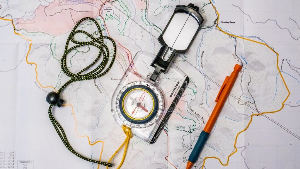
The basic pieces of equipment used for land navigation are a map of the area and a compass.
These tools are useless unless you know how to utilize them and read them properly. First, you will have to learn the basics of the compass, your basic orientation, knowing the four cardinal directions, and orienting yourself using the compass.
To understand the compass, you will need to learn about its design and features.
Compass
The compass is made of a baseplate, a plate on which the compass is set, and a direction of travel arrow set on the baseplate pointing away from the compass. Moreover, it contains a compass housing, which is a plastic circle in which the magnetic needle is found. It has a degree dial displaying all 360 degrees of the circle surrounding the housing, a magnetic needle, a non-magnetic orienting arrow, and finally, orienting lines that are parallel to the orienting arrow.
The second piece of information you will find useful is that in order for the compass to be accurate, it needs to be placed on a flat surface. After you have placed it on a flat surface, you will need to figure out the direction you are facing using the compass.
Third, and this may sound perplexing, you will have to know the difference between “magnetic north” and “true north”. Magnetic north refers to the magnetic field. In some places, depending on the surface, magnetic north may be different from true north by 20 degrees.
True north refers to the north marked on the top of the map at the point at which all longitudinal lines meet.
Cardinal directions
The main four cardinal directions, which are also the main directions on a compass, are north, east, south, and west, or you may find them by their initials N, E, S, and W.
The intercardinal directions, which are between the cardinal directions, are northeast, southeast, southwest, and northwest, or by their initials NE, SE, SW, and NW.
Between the intercardinal and cardinal directions are the secondary intercardinal directions which are west-northwest, north-northwest, north-northeast, east-northeast, east-southeast, south-southeast, south-southwest, and west-southwest.
Learning these three directions and studying how to read them is crucial to upgrade your basic orientation and land navigation, with or without tools.
Read more: How to Tell Direction Without a Compass

A key factor in how to learn land navigation is understanding the navigation terms and definitions.
- Contour lines
- Terrain features
- Declination diagram
- Azimuth
- Intersection
- Resection
- Dead reckoning
- Field expedient direction
- Map colors
- Mil to degree
Contour lines
Contour lines are lines drawn on a map that specifies ground elevation or ground depression.
There are three kinds of contour lines, intermediate, index, and supplementary. The intermediate lines are lines between the index lines, which indicate low-lying areas. The index lines indicate the elevation above sea level and are thicker lines that are numbered. Finally, supplementary lines are dotted lines showing flatter terrain or surface.
Terrain features
There are five key terrain features, hill, ridge, valley, saddle, and depression. Following the main five terrain features, there are three additional features, including draw, spur, and cliff. The last two supplementary terrain features are cut and fill.
Declination diagram
A declination diagram is a graphic diagram that indicates the relative relation between grid, true and magnetic north.
Azimuth
In a spherical coordinate system, an azimuth is an angular measurement that is the horizontal angle from a cardinal direction, generally north.
Intersection
An intersection is a method used to indicate a point located on the map by using and intersecting two lines from two known landmarks on the ground.
Resection
A resection is a method used to indicate your own location on the map by using and intersecting lines from two known landmarks on the ground.
Dead reckoning
Dead reckoning is a method used for navigation in order to calculate the contemporary position of a moving object using its previously determined location.
Field expedient direction
A field expedient direction is a method used to orient yourself by using different techniques.
One of these techniques is using your shadow or using the help of a shadow of an object. The second technique is using a watch to indicate true north and true south with the help of the sun. And the third technique is the star method, which is using the stars at night to navigate or orient yourself by finding true south and true north.
Map colors
Topographic maps use colors to indicate a terrain. Blue is used to indicate water, green is used for a forest or to specify vegetation, black color is used to indicate roads, paths, or buildings, and white is used to specify an open terrain.
Mil to degree
A useful skill is to know how to convert mils to degrees. One mil equals 0.05625 degrees, two mils equal 0.1125 degrees, three mils equal 0.16875 degrees, five mils equal 0.28125, etc.
Also read: How to Survive in the Woods Without Supplies
Conclusion
Now that you know the basics of how to learn land navigation, you can go ahead with the learning process and necessities for land navigation to be able to later successfully apply them if needed.
In a world where smart technology is striving and evolving, learning the basics of land navigation is a smart move since we cannot rely on technology 100% all the time. Everyone should know how to orient and navigate regardless of the situation.
